
April 3rd, 2025 Local News
Photo: Flooding at Forest Park Parkway and Union Blvd. in St. Louis, MO (Stitch Benson, Twitter)
Early Tuesday morning proved treacherous for motorists traveling in the St. Louis area, as heavy rainfall dropped several inches of precipitation, some areas seeing rates of 2” per hour.
A complex of thunderstorms set up roughly along the I-70 corridor in Missouri and I-64 corridor in Illinois Monday night. Several rounds of thunderstorms affected this area, including the St. Louis metropolitan area, through the early hours of Tuesday and into the morning commute. Most of the area saw at least a few inches of rainfall with a narrow band of 6” to 12” stretching from east central Missouri to southwest Illinois.
Upwards of 11" of rain fell over the course of roughly 8 hours in an axis from Hawk Point to St. Peters, according to radar-estimated rainfall and several spotter reports to the National Weather Service in St. Louis. A longer axis of over 8" of rain fell from northern Montgomery County in Missouri to St. Clair County in Illinois, causing multiple swift water rescues and scores of flooded interstates and homes across the St. Louis metropolitan area.
St. Louis-Lambert International Airport also observed a new all-time record for daily precipitation. At noon on Tuesday, the airport recorded 8.60" of rain since midnight. This broke the previous record of 6.85", which occurred on August 20th, 1915 due to the remnants of the Galveston 1915 Hurricane. The storm-total rainfall as of 2 p.m. was 9.06", but spans a two day period.
One fatality was reported in St. Louis City, where a man drowned in his car near Skinker Blvd.
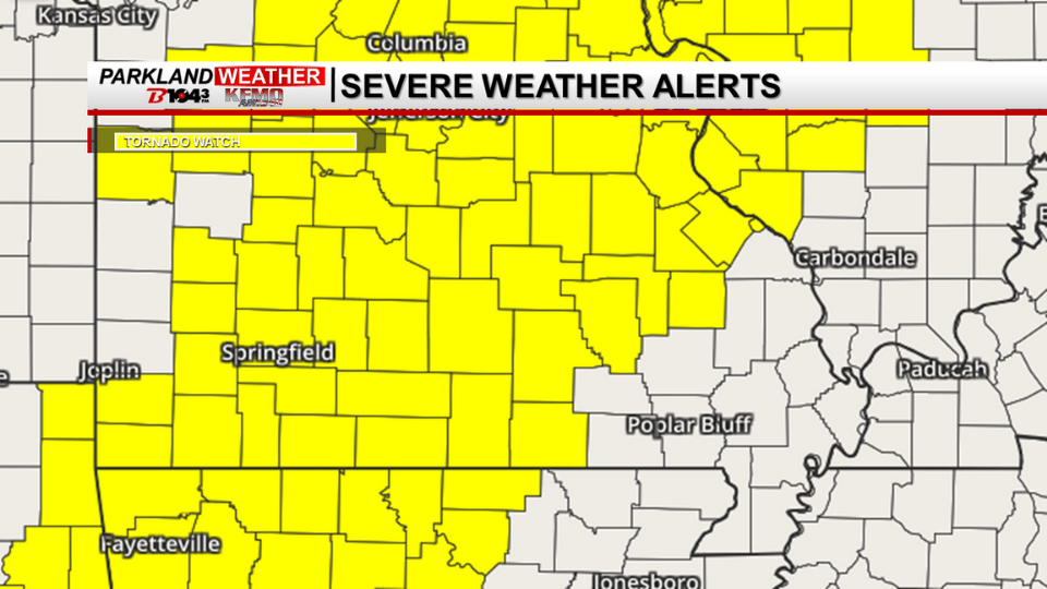
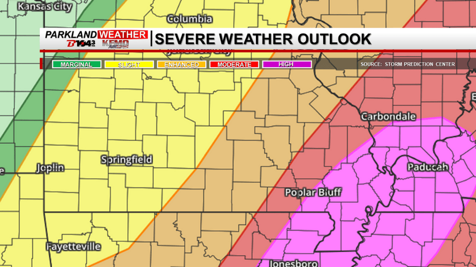
More rain is likely overnight into Wednesday, to add to the already soaked ground.
Early Tuesday morning proved treacherous for motorists traveling in the St. Louis area, as heavy rainfall dropped several inches of precipitation, some areas seeing rates of 2” per hour.
A complex of thunderstorms set up roughly along the I-70 corridor in Missouri and I-64 corridor in Illinois Monday night. Several rounds of thunderstorms affected this area, including the St. Louis metropolitan area, through the early hours of Tuesday and into the morning commute. Most of the area saw at least a few inches of rainfall with a narrow band of 6” to 12” stretching from east central Missouri to southwest Illinois.
Upwards of 11" of rain fell over the course of roughly 8 hours in an axis from Hawk Point to St. Peters, according to radar-estimated rainfall and several spotter reports to the National Weather Service in St. Louis. A longer axis of over 8" of rain fell from northern Montgomery County in Missouri to St. Clair County in Illinois, causing multiple swift water rescues and scores of flooded interstates and homes across the St. Louis metropolitan area.
St. Louis-Lambert International Airport also observed a new all-time record for daily precipitation. At noon on Tuesday, the airport recorded 8.60" of rain since midnight. This broke the previous record of 6.85", which occurred on August 20th, 1915 due to the remnants of the Galveston 1915 Hurricane. The storm-total rainfall as of 2 p.m. was 9.06", but spans a two day period.
One fatality was reported in St. Louis City, where a man drowned in his car near Skinker Blvd.
More rain is likely overnight into Wednesday, to add to the already soaked ground.